Convective Outlook UPDATED: Enhanced risk 15/04/2026 06:00 - 16/04/2026 05:59
- Hand ry

- Apr 15
- 2 min read
A cold front will move northeastward and weaken early Wednesday, introducing more moist air in its wake.
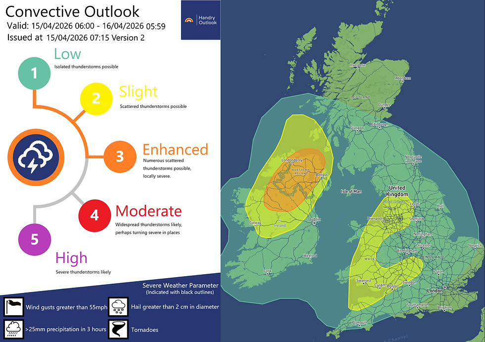
Current radar observation shows the cold front is weakening slightly more drastically than expected, meaning that cloud covers across Ireland and Northern Ireland will be lower, hence increase day-time heating, providing more energy for thunderstorms to develop.
Moisture carried by southwesterly winds will provide a window for thunderstorms to break out across Ireland, eventually tracking northeast into Northern Ireland and parts of Scotland. Most Unstable CAPE (MUCAPE) may exceed 700 J/kg across inland and eastern Ireland during the afternoon. Daytime heating acting on this instability will allow thunderstorms to develop widely and become organized; non-severe strong gusts and small hail are possible.
Significant vertical cloud extent and substantial CAPE <0°C will support hail growth. This is further enhanced by steep LLLRs and strong mid-level cold air. With the freezing level (0°C) reached around 850mb, there is potential for low-end severe hail. Despite moderate low-level shear and weak deep-layer shear, there is scope for hail 1–2 cm in diameter, though most should remain below severe limits. 8 km EL will also support frequent lightning in places.
Weak shearing will limited the life-span of the cells in the early afternoon, but these thunderstorms will generate outflows which should be sufficient enough to trigger plenty of neighbouring cells to develop . Latest observation suggests a less saturated profile than expected earlier, meaning that some cells especially within /south of the enhanced risk area—could be strong enough to produce frequent lightning.
Further showers, perhaps turning into a long-lasting thunderstorm or two due to stronger shearing, are also possible across parts of SW England, Wales and NW England during the second half of the afternoon, although confidence is rather low. A funnel cloud or two is possible, given low cloud base and sufficient shearing.


Comments